Technology
TSR lowers Atlantic hurricane forecast

TSR Lowers Atlantic Hurricane Forecast A Slight Reprieve, Not a Reason to Relax
1. A Subtle Shift in the Forecast Landscape
In a notable update that caught the attention of climate analysts and coastal planners alike, the UK based forecasting group Tropical Storm Risk (TSR) recently revised its projections for the 2025 Atlantic hurricane season. While earlier forecasts from spring painted a picture of an above average season with concerns rising over particularly warm Atlantic waters TSR has now trimmed its expectations slightly, predicting fewer named storms and a reduced chance of intense hurricane activity. Though the change is marginal, it reflects growing uncertainty about how various oceanic and atmospheric forces will interact in the coming months.
2. From High Alert to Cautious Monitoring
TSR’s latest forecast, released in early July, now anticipates 15 named storms, 7 hurricanes, and 3 major hurricanes (Category 3 or higher). This represents a modest dip from the earlier prediction of 16 named storms, 8 hurricanes, and 4 majors. Additionally, the expected Accumulated Cyclone Energy (ACE) a key metric for gauging the overall energy and longevity of a hurricane season has been reduced to 126, down from the previous forecast of 146. While these numbers still indicate a season close to the long term average, they suggest a return to median conditions rather than an exceptionally intense year.
3. Changing Climate Signals Behind the Adjustment
The downward revision is largely attributed to evolving environmental indicators. Sea surface temperatures in the tropical Atlantic, while still above average, have not warmed as aggressively as some models initially projected. Meanwhile, upper level wind patterns especially wind shear, which disrupts storm formation are expected to remain more stable. TSR analysts also cited uncertainty in Saharan dust movements, which can suppress storm development by cooling the ocean surface and drying the air. These small shifts in atmospheric stability and ocean warmth can dramatically alter hurricane trajectories and intensities, especially during peak season months like August and September.
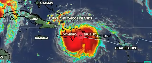
4. Reduced U.S. Landfall Risk Relief with Caveats
Perhaps most relevant to residents and businesses along the Atlantic coast, TSR has also reduced the likelihood of hurricane landfalls in the U.S. The updated forecast now predicts two hurricanes and four tropical storms making landfall, slightly fewer than previously estimated. While this change provides a degree of relief especially for insurers, emergency management officials, and coastal communities it doesn’t eliminate the risk. As experts often emphasize, it only takes one storm making landfall in a densely populated area to cause catastrophic damage, regardless of how many systems form in total.
5. A Global Pattern of Weather Extremes
This slight downgrading in the Atlantic basin is happening against a backdrop of extreme weather worldwide. Europe is currently grappling with intense heatwaves and wildfires, while parts of South America are experiencing an unusual cold snap. Some meteorologists argue that these hemispheric anomalies are part of a broader pattern of climate volatility, which may also play a role in shaping tropical activity. It’s this interplay between global climate systems rising ocean temperatures in one region, atmospheric instability in another that makes long term storm forecasting increasingly complex, even with modern satellite data and modeling tools.
6. Why This Forecast Still Matters
Even though TSR has lowered its forecast, the Atlantic hurricane season remains a serious threat for millions of people. Communities in Florida, the Gulf Coast, the Caribbean, and parts of the southeastern United States are all within striking distance of storms that can form with relatively little notice. A slower than expected start to the season or a minor drop in projected storm totals should never be interpreted as a green light to let down your guard. Emergency planners are urging citizens to treat this season like any other have evacuation plans, secure insurance coverage, and stay informed through trusted weather services.
7. Lessons from History Low Forecasts, High Impact
History offers multiple examples of seemingly quiet hurricane seasons producing devastating events. The 1992 season, for instance, had only seven named storms but one of them was Hurricane Andrew, which struck Florida as a Category 5 and caused over $25 billion in damage. Similarly, in 2019, most of the season was considered unremarkable until Hurricane Dorian devastated parts of the Bahamas. These events serve as potent reminders that forecast quantity does not equate to impact severity. What matters most is not how many storms occur, but where and how they make landfall.
Conclusion Stay Ready, Not Complacent
TSR’s updated outlook may offer mild reassurance, but it’s not a cause for complacency. Forecasting tropical storms is a constantly shifting science, affected by dozens of variables that can change rapidly. This year’s Atlantic hurricane season may now be tracking toward average levels of activity but “average” in the Atlantic still means the potential for powerful, damaging storms.
The message from experts remains unchanged prepare early, stay alert, and take all watches and warnings seriously. One storm is all it takes to transform a season from forgettable to historic.